![]()
Myth Thwitzerland
Richard Law, UTC 2015-11-11 08:44
A courtly procession
On 15 November 1315 – 700 years ago – a small army of noble knights accompanied on foot by assorted pages, vassals, peasants and camp-followers set off from the town of Zug in Switzerland.
The knights were Austrians, Germans and Swiss (in so far as it is possible to speak of these nationalities at that time) and this expedition was intended to be a punishment action against the refractory and unruly inhabitants of Canton Schwyz. They had caused much trouble in the preceding years and needed to be taught a lesson.
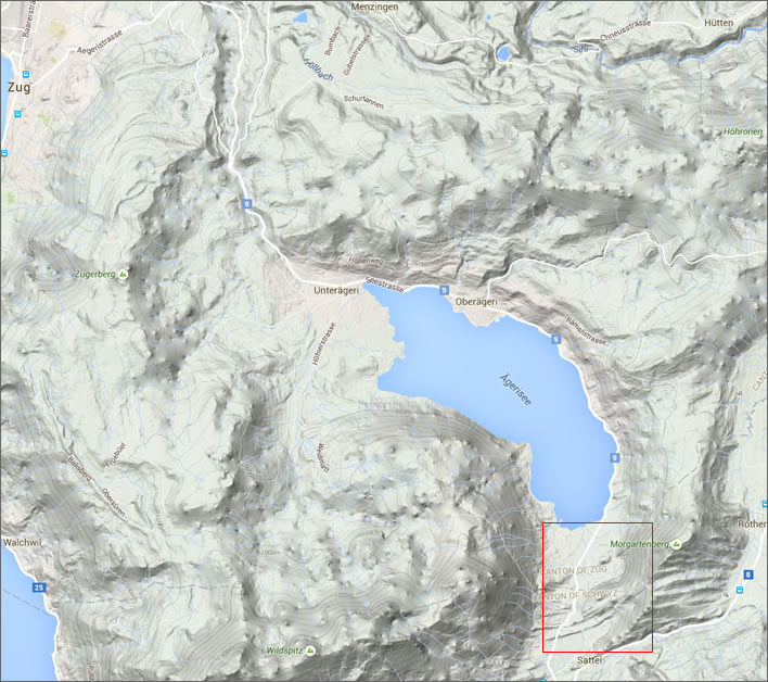
The town of Zug, Leopold's starting point, is top left. Red rectangle: Morgarten battlefield. His march took him along the north-western shore of the lake.
The mounted knights were at the front of the column, ordered according to rank after their feudal lord, the 25 year-old Duke Leopold I von Habsburg (1290-1326). They followed the track along the north-western shoreline of the Aegeri Lake, under the flanks of the hills that edge this post-glacial basin. The Aegeri Lake isn't big – barely six kilometres from one end to the other.
When they reached the end of the lake they turned left to follow the narrow track that zigzagged up along the base of steep scarps and through narrow gullies to the village of Sattel, on the main route to the capital of the canton, the town of Schwyz. We don't really know why they chose this route or where they were headed. Wherever it was, they never made it.
Chopping up the toffs, very small
Stretched out along the lake shore and in this narrow terrain the column might have been up to several kilometres long. As the knights at its head reached the end of the final gulley their exit was blocked. Suddenly hairy, uncouth Swiss peasants appeared on the hillsides around them and started bombarding them with stones. The projectiles killed and injured humans and horses, panicking both.
The attacks took place simultaneously at several points along the column as it snaked back down and along the shore of the lake. Tree trunks were rolled down at certain points, splitting the column up into sections and hindering escape: for those in the middle of these sections there was no way back out of the chaos. The defenders, armed with long handled axes with spiked tops, the infamous Swiss 'halberds', descended upon the helpless knights and massacred them brutally. A sword was no match for the defenders' long pikes and axes.
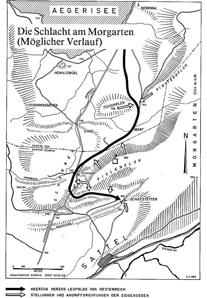
This map shows a reconstruction of Leopold's route (black line) and the Swiss attack points (white arrows). It was made in 1965 for the 650th anniversary of the battle. In terms of the battlefield as it is today (and it presumably was in 1965) I can make no sense of its depiction of the last third of Leopold's march. The topography of the battlefield as drawn does not agree with the modern landscape. The errors suggest that the creator of the map had never been to the site and therefore stood in the great tradition of all the other illustrators of the battle over the centuries. The basic topography makes no sense and therefore Leopold's route can make no sense either. However, for fifty years this map has been reproduced and adults and children have pored sagely over it.
The defenders showed no mercy to their attackers and, as far as we know, no prisoners were taken. The Swiss were not there to gain courtly battle honours. They were not bound by the chivalric conventions of knightly combat nor were they protected by them either: they killed their enemy as their enemy would have killed them. As far as they were concerned, these noble foreigners were on their way to destroy their towns and villages, kill them and their families, destroy their stores and slaughter their livestock. Any peasants left alive after the onslaughts would have barely been able to survive the privations of the imminent winter.
The Swiss defenders were not merely simple peasants fighting for their farms and homesteads either: quite a number of them would have seen service as mercenaries – hence the presence of halberds – and they could also count on the assistance of the local nobility.
Once the trap had closed, Leopold's mounted knights could do nothing except try to save themselves. For most there was no escape from the narrow track and the soggy landscape. Those who did manage to break away from the column ended up in the many swamps in the locality or in the Aegeri Lake itself, where they drowned or were hacked to pieces. Most of the foot soldiers bringing up the rear of the column were still outside the killing zone and seem to have been able to make good their escape.
The apparently selective massacre of the nobility has laid a democratic, revolutionary patina over the historical battle. Duke Leopold managed to escape somehow. We can only assume that he was able to use the local knowledge of the guide who was undoubtedly with him at the front of the column.
This was not what medieval war was supposed to be like. Chivalrous, noble knights were supposed to confront each other at a mutually agreed place and time and do battle according to set rules. We can imagine that Duke Leopold had assumed, quite reasonably, that there were not many local knights in the area to confront his army, the flower of south German nobility. As a result he wouldn't have been expecting a set piece battle, let alone a peasant ambush.
The knights in the column would not even have been properly battle-ready at the moment the attack took place: they would certainly not have been riding along in full combat gear. Their pages would be carrying their helmets and heaviest armour. Their horses were strong, capable of bearing them into combat in full armour, but no horse was capable of carrying its rider long distances across land in full battle armour and no rider would jog along for hours with his head in an iron bucket.
It is sometimes said that the Battle of Morgarten was a milestone on the road to using infantry as a strategic and tactical force. It was certainly a step towards the end of the medieval idea of war as the mounted combat of noble knights according to a code of chivalry.
The cloud of unknowing
The story of the battle given above, even in this cleaned up version without all the ornamental details that are frequently attached, is in almost all its points a fabrication. We know next to nothing about the battle with any reasonable certainty. Many aspects of the story of the battle, considered calmly, seem extremely unlikely.
We know with some confidence that some sort of an engagement between Leopold's troops and some inhabitants of Canton Schwyz took place in 1315. We think we know that it took place in November somewhere between Morgarten and Sattel in Switzerland. And that is about it.
We have no idea at what time of day the battle took place. Some say, on no evidence whatsoever, that it was fought on a clear, moonlit night, which seems implausible, since Leopold would be unlikely to be marching his army through complex terrain in darkness without having some clear tactical reason for doing so. The defenders would have had no advantage either from trying to throw rocks in the dark.
We have no idea about the size of the attacking army: how many knights Leopold had collected and how many foot soldiers and others were involved. Likewise we have no real idea how many men took part in the battle on the defenders' side. As a result we have no real idea of casualty figures: the chroniclers, none of whom were there as eyewitnesses, go for dramatic numbers – because that's what chroniclers do. Without knowing the total number of combatants with any certainty, we can hardly begin to know the scale of the losses. We can only guess. No one can say with any certainty whether this was a significant battle or a significant skirmish.
We have no idea of how the Swiss conducted the battle. The rocks they threw have got bigger through the centuries: in later paintings the Swiss are seen to be rolling boulders over cliffs. Given the short notice the defenders had – the ride from Zug would take no more than a few hours – we disturb our minds trying to work out from where all the tree trunks came and when they were felled.
The battlefield
As a first step to clarifying these problems let us at least try to find the location of the battlefield. At the beginning of the 20th century some doubt was cast on the traditional location, arguing that the battle took place on the shores of the Aegeri Lake. A monument to the battle was even erected here. Well, we have a lake there in which soldiers might drown, but no steep sided hills by any stretch of the imagination.
On the other hand the terrain between the Aegeri Lake and Sattel, the traditional location, matches the description of the battlefield in the historical records – sort of. Here we have small cliffs and gullies from which the defenders can throw stones, but no lake in which the attackers could drown. Something is wrong here.
Let's take a look at this area as it is today. Click on the thumbnails to take a walk through the critical part of the battlefield, the Figlenfluh. It is perfectly possible that Leopold's army did not follow the Figlenfluh but took a parallel route through slightly more open country, which would just serve to make the story of the ambush even more incredible. We don't know and so we have to work with what we have. There are some comments on the individual photos in their tooltips.


![We have passed the gate and ahead is a very boggy field. Very wet, even after a very dry autumn, and these days churned up by cows. Note the hut as orientation. It can also be seen in the aerial view [photo 4].](../../img/2015/11/mg/Figlenfluh_10_084.jpg "We have passed the gate and ahead is a very boggy field. Very wet, even after a very dry autumn, and these days churned up by cows. Note the hut as orientation. It can also be seen in the aerial view [photo 4].")


Let us consider the relationship of the modern landscape we see here to the landscape Leopold would have seen in 1315.
- The original access route to the battlefield has been completely wrecked. The main road from Morgarten to Sattel cuts through the old route at least twice. Local roads and agricultural development have also interfered with the old tracks. And finally, in the last few years, to mark the 700 year anniversary, all the 'improvements' – the widening of the main road, the building of a car park and Information Centre – have finally destroyed what little was left here. [By the way: the signposting is obscure and misleading: you have to be quite determined if you want to find the battlefield from the car park.]
- The terrain of this area is uniformly boggy. The local climate is wet, dark and cold.
- The general structure of the landscape is a series of escarpments: gentle basins edged by steep rocky outcrops running across the line of ascent to Sattel. These basins and gullies would hold water and form the marshes and pools that we are told caused Leopold's mounted soldiers such problems. The scarps formed natural barriers across the route, forcing the troops to zigzag up the hill along the 'Fluhe'. Fluh is a Swiss-German word for a deep, generally dank and agriculturally useless gulley, usually with a stream running along the bottom.
- Seven hundred years of relatively undisturbed deciduous woodland in the gullies have raised the level of the forest floor substantially. I don't have exact figures for this process, since deposition of soil depends so much on local circumstances, but based on the carbon dating of soil samples in the locality it seems safe to assume that the bottom of the Figlenfluh was possibly two or more metres lower in 1315 than it is today. It also seems reasonable to expect that the woodland in it was denser and much more impenetrable than today.
- For seven hundred years since the battle the landscape has been worked and farmed and grazed and smoothed. The seasons have marched on, gradually filling up the troughs and eroding the ridges. The woodlands have been felled, only a few coppices remain. The level of the lake has sunk and the small lakes and swamps have dried up or been drained by humans, so that what was once marshy terrain is now agricultural land, albeit still very wet.
Allowing for all the changes that have taken place in this landscape over the centuries, we can still see that a route through the Figlenfluh was extremely well suited for an ambush of mounted soldiers. Sticky soil, dense tree cover, rocky, wooded slopes and cliff escarpments cutting off exit routes on both sides: no sane mounted force would want to be in this situation. The towering cliffs and lakes of legend were not really necessary.
Well, we may have found the dangerous banks and gullies, but where are the marshes and the lake into which Leopold's troop blundered while trying to escape? They are a long way away in this modern landscape.
Drowning in uncertainty
In 2013 a team from the University of Zurich did some empirical research on a particularly critical aspect of the battlefield: the level of the Aegeri Lake at the time of the battle. [1]
It appears that the lake was between two and three metres higher then than it is now. Importantly, the area through which Leopold was passing was wet fenland with one or more ponds or small, shallow lakes. Our own visit to the battlefield makes this a highly credible scenario. Even today the terrain is soggy and unpleasant. Leopold would have had very few options to pass through this fenland from the shore of the Aegeri Lake up to Sattel. There would certainly have been no easy escape for mounted troops in this terrain, even if they got out of the gullies. Whether it would have been possible for knights to drown in these shallow waters is a question we unfortunately have to leave unanswered.
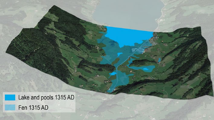
Lakes, ponds and fens around 1315. Note the swampy fenland and ponds of the battlefield at the middle right of the image.
Image: Egli et al., 'Multi-methodological reconstruction… in The Holocene, 2015, p. 1-15.
It would indeed have been a narrow and problematic route for an army of mounted knights; Leopold's local guide would have been essential. The tracks that ran under steep hillsides and through gullies were his only option – and the Swiss defenders knew it.
For anyone approaching from below the difficulties are hidden. It is true that Leopold would have seen the same scarp face we now see from the road, but his guide chose the path that took him through and behind that and into the Figlenfluh. Leopold and his men could only follow his guide. Would history have been different had Leopold and his senior commanders been able to see in advance what they were riding into? Once they were there it was too late: on a narrow track a mounted column cannot fold upon itself and return. If our speculations are correct, questions must be asked. To whom did Leopold's local guide owe his loyalty? Did he lead Leopold and his men into the difficulties of this terrain deliberately?
And there are even more puzzles to be solved. Why did Duke Leopold come this way at all? If he was wanting to go from Zug to Schwyz why did he take this risky and narrow route instead of the much easier route via Arth? Perhaps he wanted to get to the Abbey of Einsiedeln instead, which had been particularly affected by the unrest of the natives. This would make the route more plausible. Some say he was planning a surprise attack on Schwyz from an unexpected direction. What happened certainly surprised him.
One final thing is still puzzling about this battlefield: if the story is true that the flower of south German and Austrian nobility was massacred or drowned here, why has not one single artefact from the battle ever been found on the battlefield? No rings, no coins, no daggers – nothing. The University of Zurich researchers took many soil samples from the battlefield and its vicinity and explicitly report that they found nothing, which surprised them as much as it surprises us.[2]We might be justified in asking:
Was there ever a Battle of Morgarten?
In order to answer this question convincingly we need to do what historians always should do: go to the sources.[3]
The first we hear about the event is an entry in the chronicle Chronicon Aulae Regiae dated 1316, that is, one year after the presumed date of the battle. The chronicle was maintained by the Abbots of the Cistercian monastery of Königsaal (hence Aulae Regiae) near Prague. The entry says no more than that Duke Leopold had led a campaign with 2,000 men against the Swiss cantons of Schwyz and Uri. At that time Königsaal (nowadays called Zbraslav) was in Bohemia, a country that was very much part of the Habsburg empire, but still a long way away from Schwyz. The entry is therefore relatively contemporaneous with the event but it is not a local record by an eyewitness.
Then there is silence for around 20 years, until in 1338 the 'Chronicle of the Upper Rhine' mentions laconically that 'around this time the great conflict took place in Schwyz and the Duke lost great people' (Whether 'great' here means 'great in number' or 'great in rank' is open to interpretation). We must not forget that this remark was made nearly a generation after the event and that the memory of whatever happened on Leopold's expedition is already starting to fade in the minds of the population.
The next report was written between 1340 and 1344 by another Cistercian chronicler, Johannes von Viktring (1270?-1345?), Abbot of the monastery of Viktring, near Klagenfurt in Austria. As we move further away from the event itself, details start to be added to the tale: always a warning sign in historical records.
Leopold … attacked the Swiss, who were inexperienced in the use of weapons and who had grown up to be only shepherds or husbandrymen, with a strong and glittering army of knights and nobles. … They allowed the Duke to enter [their territory] but then suddenly rebelled in the narrow confines of the mountains in that they descended from the mountains like mountain goats, threw stones and killed those who could not defend themselves or escape in some way. …It can be said that the flower of the knightly company was destroyed.[4]
With this account, 20 or more years after the event, three themes have emerged: the simple Swiss defeat the glittering nobles; the nobles were ambushed in difficult terrain; the defeat was brutal and decisive.
A few years later we learn yet more details from a Franciscan friar, Johannes von Winterthur, writing a chronicle between 1340 and 1348. Johannes goes out of his way to claim authority for his account: Duke Leopold turned up in the Abbey of Winterthur (in Switzerland) looking 'half-dead from extreme grief' and that he, Johannes, 'had seen this with his own eyes as a schoolchild'. [5]Reading his account we go from a state of knowing almost nothing to drowning in picturesque details.
On the day before the feast day of Saint Otmar[6] Duke Leopold and his troops wanted to enter Schwyz on a route between a hill and a lake, known as the Aegeri Lake. He was hindered by the steepness of the hillside and the height of the hill. The knights were unable to ascend the hill; even the foot soldiers could scarcely move or stand. The Swiss knew … that they would be attacked there … they stormed out of their hiding places full of courage and resolution and attacked the enemy, who were like fish on a line, defeating them without any resistance. … The Swiss were wearing crampons on their feet that allowed them to stand on very steep slopes, whilst their enemies, even those on foot, could not get a grip. The Swiss were equipped with halberds, terrible weapons, with which they could open the best armoured enemy soldiers as though with a pair of scissors and them chop them up into pieces. … Those who were not killed drowned in the lake attempting to get away. … It is reported that 1,500 men were killed, without counting those drowned. … As a result of the loss of knights they were scarce in the surrounding areas for a long time. From every castle and town several were killed. [7]
Yes there was, but…
After reading these three sources we can probably believe that Leopold and his knights suffered some setback. However, we do not have a single report from an eyewitness. As far as Johannes von Winterthur is concerned, we are reading the adult's recollections of the oral tales he was told as a child. Most of the eyewitnesses to the battle would have been dead by then. Johannes himself – an eyewitness to the arrival of Leopold at the Abbey of Winterthur but nothing else – would not last much longer than a year or so after this account was written. A generation had passed in the meantime.
Nevertheless the main outlines of the battle – the general location, the terrain, the ambush, the brutal victory for the defenders – might seem credible. Would a chronicler make all that up? Yes. There are a number of reasons for treating what Johannes has written with with great scepticism – the account is simply too overwrought, but we don't have space to go into all that here.[8]
From Johannes we get a date: 15 November 1315. We have no other confirmation for that. It is, however, interesting that according to Johannes, Duke Leopold turned up at the Abbey of Winterthur after this event. Later accounts, even less founded, have Leopold fleeing to the other side of the lake and returning presumably to Zug. In itself this is a highly problematic escape route that exposes him to many risks. He has to fight his way back down his convey and come out close to their rear. This explanation is barely credible and can be discounted immediately, as long as we assume that there was a serious battle and the attacking column was in disarray. It also seems strange behaviour to return to Zug and then go immediately ('half-dead from extreme grief') to Winterthur and not his home territory on the Rhine.
These problems are resolved to some extent if we assume that the more obvious escape route would be forwards. Perhaps the front of the convey was imperfectly blocked and Leopold, his guides (with or without the senior knights around him) were able to surge forward and follow a route up to Sattel then across to Einsiedeln and from there onwards past the Lake of Zurich to Winterthur and safe territory. There may be some reason to believe the only part of the account of Johannes for which he himself was the eyewitness.
Even then his testimony is suspect: since he asserted that Leopold had lost 20,000 troops in the battle – an absurdly high number – when Leopold arrives he therefore has to be 'half-dead from extreme grief'. The entire conclusion of the battle, the dispersal of Leopold's troops, if indeed they were dispersed, and all the other events that would have to take place following such a major defeat go unexplained.
As far as sources go, that is it. That is the last near contemporaneous account from someone who was not present but had an unforgettable encounter as a child when Duke Leopold arrived, miserable after his defeat or setback, and then remembered the second and third-hand tales that came his way during his life. All the other accounts that follow are just unfounded embroidery.
In our opinion Johannes von Winterthur's account should be disregarded in almost all of its elements. All the subsequent chroniclers have only elaborated his fantasy. On the basis of his account we have spent centuries looking for combinations of cliffs, gullies and lakes that match his description and bent the evidence of our own eyes to find some validation of his tale. No validation is possible because it is not true. For centuries we have overlooked all the many practical difficulties contained in his tale. Why? Because we want to believe; in this state the magical storyteller can conjure up any phantom:
Only believe me. Ye believe?
Appears Verona... [9]
When we finally throw his fairy tale into the dustbin we can begin to look at the event in a rational, evidence-based light.
A catastrophe, a skirmish or a setback?
How important was the Battle of Morgarten? How many combatants took part? What were the losses on each side?
The latest guesswork puts the strength of the Austrian, German and Swiss troops at several thousand, both mounted and foot soldiers. Leopold would be unlikely to risk an incursion into enemy territory with fewer soldiers. There were probably about a thousand Swiss combatants against him. In difficult terrain and with the advantage of surprise it is reasonable that a thousand inflamed Swiss foot soldiers could have the advantage over several thousand enemy, some proportion of them mounted. If the Austrian troops were reduced to a thin convoy along narrow tracks then the advantage could be much greater.
The latest estimates of losses using studies of death registers and obituary books give a figure of a few hundred dead knights and foot soldiers from Leopold's army and only a few dead Swiss defenders, which means that for Leopold, the losses arising from his punishment expedition into Schwyz were not as catastrophic as his enemies and chroniclers have maintained. Nevertheless the expedition not only brought him no benefits at all but the encounter at Morgarten – whether battle or skirmish – certainly motivated his opponents to acts of future defiance.
Mything in action
The story of the Battle of Morgarten as we have told it is a slightly sanitized version of the one in circulation today. Reputable Swiss historians inspect their fingernails and shuffle their feet when asked about the event. The mythology has evolved over a period of seven centuries and it is scarcely conceivable that we can go back to a more realistic view of Morgarten.
Seven hundred years of imaginative effort have created an image of heroic Swiss farmers rolling boulders and tree trunks over towering cliffs onto the terrified mounted knights below, where other Swiss chop them to pieces with their halberds. As we have seen, when we inspect the landscape, which the illustrators and chroniclers never did, we find a completely different scene.
, Morgartenschlacht, Rathaus, Schwyz, Switzerland")
This is the most famous representation of the Battle of Morgarten. It was painted on the outside of the town hall of Schwyz in 1891 by Ferdinand Wagner (1847-1927), a German painter from Bavaria.
There is not one single element in this painting that could be said to have any basis in historical reality. The action appears to be taking place beneath a non-existent cliff next to the Aegeri Lake. A hundred years later this location is now generally regarded as wrong. The wrongly located monument is still there, though, and some still gather there on the anniversaries. The tower in the background seems to be the Letziturm, which had not been built at the time of the battle. Some troops appear to be marching against Leopold from that direction, carrying the flags of the three initial confederacy cantons: Uri (the bull's head), Schwyz (the red flag with the cross) and Unterwalden (the flag with the key). This nonsense has been on the front of the Town Hall in Schwyz for more than a hundred years.
Nowadays, on the great day itself, Swiss men parade onto the battlefield in white smocks carrying halberds. There is a pistol and rifle shooting competition, which signifies the militia army that has been at the heart of Swiss life for so long, the roots of which go back to the patriotic defenders at Morgarten. It is an image of the Swiss policy of armed neutrality: we leave you alone, but attack us and you will suffer. Speeches will be made by politicians and local worthies claiming Morgarten to be one of the first glorious steps on the road to freedom, self-determination and independence for the Swiss Confederation. If only Johannes von Winterthur could see what his tale had started!
Getting along with the neighbours
The danger of myths, though, is that they hide the hard realities of history. Over a couple of centuries the Swiss were indeed able to build a multi-lingual, multi-faith, democratic confederation. Then in 1798 Napoleon came to call and put an end to this democracy lark for a while. Resistance was futile, but there were many Swiss who were not unhappy at his presence. After he had been finally deposed by the great nations of Europe in 1815, the Swiss settled back into refining their confederacy. For a long time the Swiss Confederation, offering freedom and protection for other nations' troublemakers, has been a welcome bastion against the totalitarian forces of Europe.
Until, that is, a German Napoleon called Adolf Hitler came to power. The Swiss, once more outnumbered and outgunned, made a defensive plan that, in case of attack, would leave the populous parts of Switzerland, the lowland towns and cities, to the Teuton hordes and withdraw the army to bunkers in the mountains to defend rock formations. In its main points the plan is reminiscent of Morgarten. Fortunately, this plan was never tested, which in itself is considered to be a victory by the Swiss.
But the reality is that, compared to the rolling lands and resources of eastern Europe, its mines, agriculture and oil reserves, Switzerland had no appreciable resources whatsoever. As a result, Germany busied itself in the east and the west and left little Switzerland more or less alone. Foreign policy was always the weak point for this small nation with no resources but with big neighbours.
There used to be independent Swiss banks, until the USA and the EU decided to squash them in one way or another. The people spoke and Switzerland stayed out of the EU, only to bow to the inevitable and sign up to a growing range of bilateral treaties with the new big neighbour that now surrounded it on all sides. What else could it do? It has signed up to various international treaties in law and trade. After centuries of staying clear of foreign entanglements it has now even joined the UN and is starting to participate in conflicts in foreign countries. Its freedom of manoeuvre is currently extremely limited, probably almost as much as that of a full member of the EU. Jobs, trade and prosperity would seemingly all be at risk were this not so and, as we know too well, they are much more important that freedom and self-determination.
The danger of the myth of Morgarten is that it allows the Swiss to celebrate freedom, autonomy and independence from the oppressor, overlooking the fact that they no longer have any of these. Theirs is just another country.
So after the Morgarten festivities have ended the political leaders will return to their parliaments to add the finishing touches to the latest proposal to join the European Union. That strange chuckling sound you can hear? Must be Duke Leopold.
References
-
^
Egli et al., 'Multi-methodological reconstruction of the lake level at Morgarten in the context of the history of the Swiss Confederation' in The Holocene, November 2015, p. 1-15.
Paywalled journal -
^
This statement that no artefacts have been found is not strictly true, but true enough. As part of the run up to the 700 year anniversary the Swiss television science programme Einstein in February 2015 commissioned two metal detector fans to look for treasure. They couldn't look on the main battlefield, since it was still covered in snow (what a surprise that must have been!). They found some artefacts somewhere near the Tschupplen site but there is no evidence these are anything to do with the battle. They returned to the main site after the snow had melted but found nothing, finally realising that if there had been anything there it would be several metres below the surface by now and thus undetectable. Concluding this infantile buffoonery, Swiss television called the finds a 'sensation'.
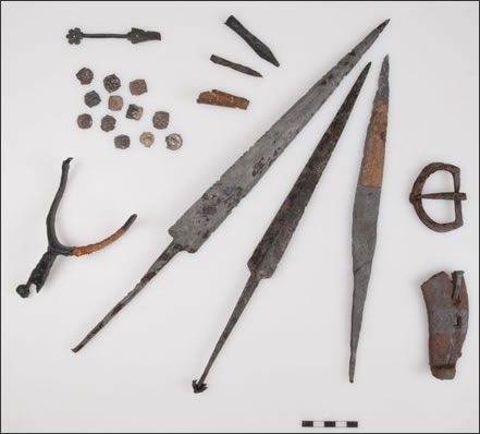
Group of Late Middle Age artefacts (from left): spur, box closure, 12 silver coins, metal capping of a knife holster, two arrow heads, two daggers, knife, belt buckle, horseshoe.
The broadcast (Swiss German) is here. - ^ The best and most authoritative brief historical account of the Battle of Morgarten is here (unfortunately only in German):Historisches Lexikon der Schweiz, Morgarten
- ^ If your monkish Latin is up to it, Johann von Viktring's chronicle is here:Iohannis abbatis Victoriensis, Liber certarum historiarum. Teil II, p. 70.
- ^ Saint Otmar (689?-759) was the first Abbot of the Monastery of St. Gallen and so a popular local saint in eastern Switzerland. His memorial day falls on 16 November, which means the the Battle of Morgarten took place on 15 November.
- ^ Die Chronik Johanns von Winterthur, p. 80
- ^ ibid, p. 79f
-
^
Johann structured his tale around allusions to and near quotations from the Bible. There is a discussion of this subject and an assessment of his credibility as a chronicler here (in German):
Hermann Schlapp, 'Vitodurans Interpretation der Morgartenschlacht'. - ^ Robert Browning (1812-1889), 'Sordello' (1840)
0 Comments
Server date and time:
Browser date and time:
Input rules for comments: No HTML, no images. Comments can be nested to a depth of eight. Surround a long quotation with curly braces: {blockquote}. Well-formed URLs will be rendered as links automatically. Do not click on links unless you are confident that they are safe. You have been warned!